Фотоальбом ТЮМЕНСКАЯ СТОРОНА |
Забыть Народную! (стр. 162-167)
Гора Народная находится на Приполярном Урале, в Югре (ХМАО), в 0,4 км на восток от главного уральского водораздела, в истоках р. Народа (бассейн Оби), на стыке Исследовательского и Народоитьинского кряжей. Высшая вершина Урала, высота 1895 м. Вершина со стороны реки Балбанью (лев. приток р. Кожим) напоминает массивный каменный шатер. У северо-восточного основания залегает оз. Голубое.
В 1927 году отрядом Североуральской комплексной экспедиции Академии наук и «Уралплана» под руководством А.Н. Алёшкова определена как высшая вершина всего Урала. Названа им же, посчитавшим ее безымянной, в честь советского народа (с ударением на второй слог), отмечавшего в тот год 10-летие Октябрьской революции. Вместе с тем, автор признавал игру слов, поскольку на выбор названия повлияла стекающая с юго-западного склона река Народа.
Но! «Впервые на карту нанесена в позапрошлом веке венгерским путешественником-этнографом Анталом Регули: ему по праву принадлежит приоритет в открытии этой горы. В 1844 году во время экспедиции на Уральский Север он побывал в районе высших вершин и со слов проводников-манси впервые указал на составленной им рукописной карте местонахождение высшей уральской вершины, называемой манси Поэнурр (гора-верхушка, макушка, т.е. главная, самая высокая гора). К сожалению, труды Регули стали известны много лет спустя, а на русский язык вообще не переводились» (Е. Шубницина, 2011).
Так не стоит ли прекратить споры по поводу ударения в слове «Народная» и называть её «Поэнурр»?
Forget Narodnaya!
The Narodnaya Mountain is located in the Nether-Polar Urals, in Yugra (the Khanty-Mansiysk Autonomous District), 0.4km east from the main interstream area of the Urals, at the source of the Naroda River (the Ob River basin), and at the intersection of the Issledovatesky and Narodoityinsky ranges. With its height 1895m, it is the highest mountain of the Urals. If you look at it from the side of the Balbaniya River (left-bank tributary of the Kozhym River), it resembles a large rocky tent. At its north bottom there is the Goluboye Lake (the Blue Lake).
The history of its name «Narodnaya» dates back to 1927. It was then that the North Urals Complex Expedition under the auspices of the Academy of Sciences and Uralplan Institute was organized. It was headed by A.N. Alyoshkov and it defined the highest top of the Urals. As it was thought to be nameless, A.N.Aloyshkov proposed the name «Narodnaya» with the second syllable stressed (translated as «People’s») in honor of the Soviet people, who celebrated the tenth anniversary of the October Revolution that year. Besides, there is the Naroda River, flowing down from the southwestern slope, so the name «Narodnaya» seemed to be even more appropriate due to the word-play.
However, the first person, who mapped out the mountain, was Anthal Reguly, a Hungarian ethnographer and traveler. He did it in the 19th century, so he can be considered the person, who discovered this mountain. He was at the site of the highest tops back in 1844 during the expedition of the North Urals. According to the evidence of his Mansi guides, he showed the location of the highest top of the Urals on the manuscript map that was made up by him. The Mansis called it Poenurr (a top-mountain, a crown, i.e. the highest mountain). Unfortunately, A. Reguli’s studies became known only many years later, and they were never translated into Russian (E. Shubnitsyna, 2011).
Maybe, it would be fair to call this mountain Poenurr after all, rather than to carry on polemics, which syllable to stress in the word «Narodnaya».
Высшая вершина Урала – гора Народная (1895 м) находится в Югре (ХМАО) (1)
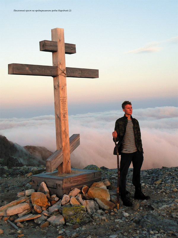
Поклонный крест на предвершинном гребне Народной (2)
На вершине горы Народной (3)
Лишайники взбираются по камням высоко в горы и могут встречаться у самых вершин


